The Nonsense of the Definitive Map BHS Access Cornwall Home Page


Another Bridleway LOST!
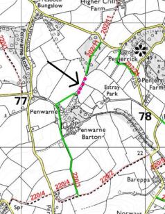
In 2002 Budock Parish Council submitted a Modification Ordern application to modify the definitive map to complete a gap in a definitive bridleway. The path in question is a bridleway lane that crosses from Budock to Mawnan and which currently has a 200 yard section of the path missing from the Definitive Map.. Now after SIX years, the County Council, following due legal process, has concluded that the two sections of bridleway are to be joined by a FOOTPATH. This will deny us access to a bridleway three quarters of a mile long!
This is another so called anomaly which is being ADDED to the definitive map.. This is it despite a key part of their recently published Cornwall Countryside Access Strategy (PRoW Improvement Plan) is to start addressing these anomalies and correct the definitive map.
The British Horse Society objected to this decision, but without support and further action from the County Council is powerless to affect the outcome...
A report by consultants for the British Horse Society concluded that the whole process of handling this Modification Order was flawed, and the issues should have been addressed at an early date when the Modification Order was first submitted.
The County Council says there is nothing it can do. We disagree, it could put forward a Creation Order to create a bridleway over the missing link. However because of likely landowner objections it will not do so.
We are dismayed that we cannot ride or get to the bridleway. The landowners will not allow access along the west farm lane either. What is the point of the bridleway being on the map? It does though count towards the 363 miles of bridleway that allegedly are there for us to ride. The landowners will not let us ride the lane to reach the bridleway!
Purple dots show length of lane to be designated as FOOTPATH!